Right now hundreds of thousands of college students are getting to know their new campuses. They’re figuring out which building to head to for their first day of class, and where to do their laundry. And potential students are taking campus tours, imagining themselves burning the midnight oil in the library and meeting their new roommate in dorms.
Some of these students are traveling campus by foot. But many of them are opening up 3D maps and taking virtual tours on their phones and laptops, thanks to location-based and virtual reality software.
College marketing departments savor at the new opportunities afforded by this technology. Schools officials can show off the campus to students who otherwise might not be able to afford a visit; take potential donors inside a yet-to-be built library that their dollars could support; ease incoming freshmen’s fears about what to expect in dorm room layouts.
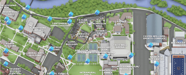
Most campus maps are flimsy brochures that gather dust in the visitor center. But to Michael Green, senior graphic designer in the marketing and communications department at Texas A&M University, maps offer an opportunity for users to have rich, interactive experiences that give them a feel for campus.
Since 2014, Green has worked with CampusBird, an interactive map and virtual tour platform, to build 3D maps and virtual tours of Texas A&M.
“Looking at a footprint of buildings doesn’t help me,” Green says. Instead, anyone with the Texas A&M app can open a map of campus that lets them navigate grounds, read details about buildings and see 360-degree panoramic images of grounds.
Green, who was an “Aggie” campus tour guide as an undergraduate, is eager to create the most realistic campus experience possible for those who might never set foot in College Station, TX. College tours are cost prohibitive for many high school students and their families—a fact that makes it even more difficult for first-generation students to envision themselves wandering grounds.
“Even in Texas there are kids who don’t have the means to visit our campus. When people go on campus tours, they’re going to apply,” Green says.
CampusBird is a product of Concept3D, a location-based software and 3D services company based in Boulder, CO. CampusBird launched in 2012 with the goal of “reinventing the campus map,” and today counts 250 schools, some with multiple campuses, among its clients.
CampusBird’s designers build 3D maps using Google Maps and OpenStreetMap. They add layers to produce 3D renderings that depict buildings and landscape features. Then users at the school can annotate the maps, adding details like the history of a building or the hours the gym is open. (Watch the map-creation process in the video below.)
CampusBird maps also include virtual tours. If a user were to click on the chemistry building, she might see a virtual depiction of the lab, for example. In the first half of 2016, users took some 80,000 virtual tours on CampusBird-powered maps.

Pricing for CampusBird largely depends on the size of the campus and additional features. Small schools can get started for $10,000 up front, while big schools interested in mapping out larger campuses with great detail including building interiors, can expect to fork over six figures.
Colorado State University, for example, commissioned a 3D map of its entire campus, but added interior maps for a couple of its main buildings, including the student center. Schools also pay a recurring annual fee for the software, hosting and features.

Green, who manages most of the mapping from the Texas A&M side, says he can grant different people access to edit different parts of the map. “I can give the library location and permissions just for their location and they can’t interfere with the dorms.”
He’s also created a series of map layers for specific events. These layers are visible only to people who are attending that particular event and expire once it’s over. For example, Texas A&M had a staff appreciation day, in which staff could get professional photos taken on campus with their families. They had access to an interactive map that told them the location of each photographer and other details including where to find free parking.
More recently, Green worked with the Residence Life department to create a map for move-in day, which included where to find cardboard recycling, aid stations and where to park to unload those IKEA dressers and bookcases. Each dorm had a unique map, “so students wouldn’t get overwhelmed with details for all of the buildings,” Green says.

Green’s next project is embedding 360-degree videos in the maps. Imagine Google Street View, but instead of a still image, there’s movement around you. “You watch a squirrel run around, a person rides by on a bike, you hear birds chirping,” he says, adding that his dream is to add a virtual reality component to it. “As you spin around you can see the Sul Ross Statue.”
Creating the videos is one step, but placing them on a map gives viewers context and a sense of place, he says. If all goes well, some 2017 freshmen will have virtually explored their dorms well before they purchased that IKEA dresser.

